Real-Time Pole Data for Every Infrastructure Need.
Engineering & Design Firms
Engineering & Design Firms
Minimize your time spent in the field with instant pole data; no special equipment needed.
Telecom & Broadband Service Providers
Telecom & Broadband Service Providers
Optimize network design and speed revenue with strategic real-time pole data.
Utility Companies & Contractors
Utility Companies & Contractors
Full pole visibility for faster planning and fewer outages.
GIS & Data Collection Firms
GIS & Data Collection Firms
Auto-captured, geo-tagged pole data immediately available for your GIS staff.
Field Data Collection & Surveying Companies
Field Data Collection & Surveying Companies
Experience easy operation, minimal training, and faster revenue generation.
Joint Use & Asset Management Firms
Joint Use & Asset Management Firms
Simplify audits and protect revenue streams with comprehensive attachment data.
Seamless Capture, Instant Insights
Unlock Accurate Pole Data Collection with Our Simple 4-Step Process
Quick Start
Master the Web Interface & Mobile App
Download our app (iPhone/iPad), quickly register your organization, and complete a brief 20-minute online training to get started immediately.
Effortless Capture
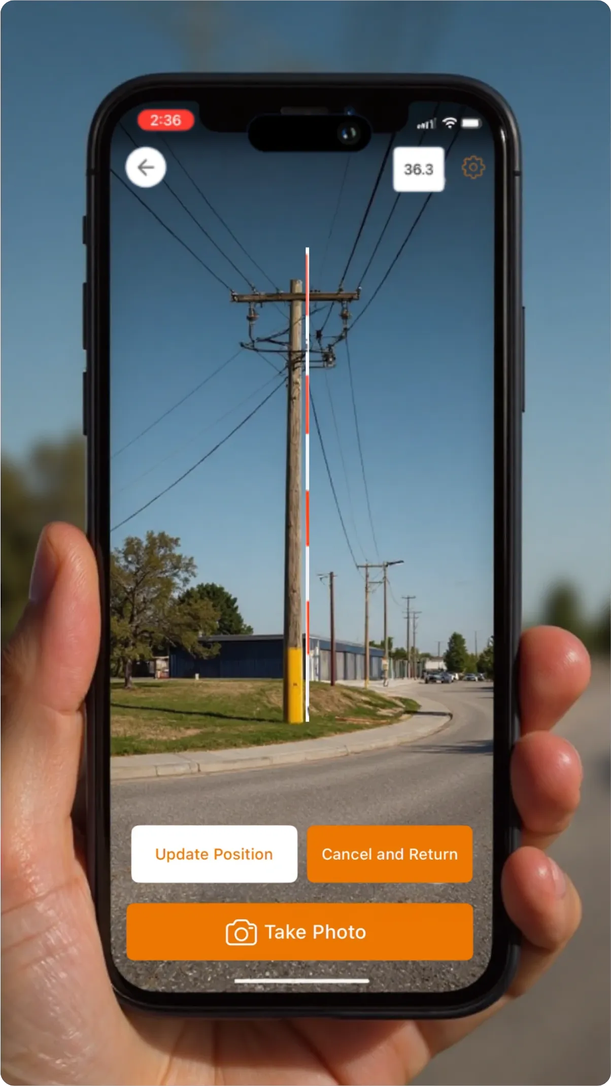
Point, Scan & Collect with Augmented Reality
Simply point your device using augmented reality to capture detailed and accurate pole attachment data instantly. It's intuitive and requires no complex steps.
Real-Time Sync
Immediate Data Access for Seamless Collaboration
Captured data instantly syncs to our secure web interface, allowing remote engineers and office teams immediate access for design, analysis, and project planning.
Analyze & Act
Access and Review Data Anytime, Anywhere
Access our secure web portal from any location to review precise measurements, manage projects efficiently, and perform real-time analysis for informed decision-making.
Features
Our Clients' Favorite Features
Effortless Data Collection
Quickly capture utility pole details with an easy-to-use mobile app.
Instant Data Sync
Keep field and office teams aligned with real-time updates.
Advanced GIS Mapping
Accurately visualize pole locations for better planning.
Comprehensive Pole Tracking
Monitor project progress with real-time status updates.
Powerful Reporting & Analytics
Turn data into actionable insights to maximize ROI.
Uninterrupted Offline Capabilities
Work anywhere with offline data capture and auto-sync.
Competitive Analysis
Outperforming the Competition
Important Industry Features
Competitor
A
B
C
Single Technician Operation
No Special Equipment Required
Zero Calibration Needed
Real-Time Data Connectivity
*
Productivity: Average Poles Surveyed Per Day
(per two person team)
180
100
90
40
High Measurement Accuracy
Minimal Training Required
Scale With Ease
Seamless Integration With Existing Systems
Simple Pricing, No Contracts, Pay As You Go
Most Efficient Pricing Structure**
13%
more
50%
more
100%
more
Value Index Score***
4.7
3.7
4.0
2.45
* Mobile Hotspot Dependent
** Modeling cost for purchasing 25,000 pole credits
*** Category weightings: Accuracy 50%; Automation 30%; Ease of Use 20%
Pricing
Flexible Pole Credit Plans for Every Project
Pole Credits
1 – 10K
10,001 – 25K
25,001 – 50K
50,001 – 100K
100K+
Price Per Pole
$ 3.00
$ 2.80
$ 2.60
$ 2.40
$ 2.20
Volume Discount
List Price
7%
13%
20%
27%
Streamline Your Workflow
Watch Real-Time Impact Unfold
Pricing
Flexible Pole Credit Plans for Every Project
1-10K Credits
Price: $3.00
10K-25K Credits
Price: $2.80
(7% Off)
25K-50K Credits
Price: $2.60
(13% Off)
50K-100K Credits
Price: $2.40
(20% Off)
>100K Credits
Price: $2.20
(27% Off)
Begin Your Free Trial
No commitment required. See the benefits firsthand
Download the App: Get started instantly by downloading the D8Acapture app.
Register Your Account: Create your free account to unlock your trial.
Enjoy 100 Free Credits: Upon registration, you'll receive 100 credits to explore all platform features.
No Commitment Required: Experience the benefits risk-free.
Company
Decades of Insight, Game-Changing Solutions.
At D8Averse, our decades of navigating the complexities of pole data for telecom and utilities gave us a clear vision: to create smarter, more efficient solutions for the infrastructure industry. We’re dedicated to empowering you with innovative tools that streamline workflows, enhance accuracy, and unlock the power of your infrastructure data.
Introducing D8Acapture, our first product designed for your needs, D8Acapture provides instant access to critical infrastructure data (‘D8A’), leading to faster projects, improved accuracy, quicker deployments, and better decisions for everyone in the infrastructure ecosystem.
Join us in building a more efficient infrastructure future, driven by practical experience and innovation.
Connect with us
Fill out the contact form to start a conversation with our experts.