As telecom and utility network deployments accelerate across fiber, wireless, and utility infrastructure, pole data capture has become a defining factor in project success. The comparison of D8Acapture vs. drone capture increasingly shapes how organizations evaluate field data collection speed, measurement accuracy, and operational scalability.
Both approaches move beyond traditional manual surveys using height sticks, measuring wheels, and paper documentation. The difference lies in workflow complexity, data readiness, and how quickly engineering teams can act.
Utility pole data collection underpins make-ready engineering, permitting, and construction. Friction at this stage can delay downstream network design, regulatory approvals, and field construction execution.
Today’s fiber and broadband deployments require more than measurements. Engineers need verified attachments, clearance data, visual documentation, and confidence that field conditions match design assumptions. The question is not whether to modernize capture methods, but which approach best fits real-world operational and deployment realities.
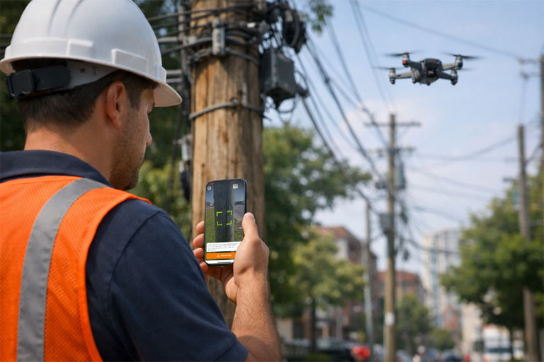
Drone capture uses unmanned aerial systems (UAS) to collect high-resolution imagery and measurement data from above. It can be effective in remote or hazardous environments where ground access is limited.
From an aerial perspective, drones can survey multiple utility poles quickly and capture broad infrastructure visibility across longer routes. However, drone workflows introduce added complexity. Flight planning, regulatory compliance, pilot certification, and weather constraints affect deployment. After flights are completed, aerial imagery and photogrammetry must be processed and interpreted before engineering teams can use the data, extending the timeline from capture to action.
D8Acapture takes a ground-based, mobile-first utility pole data capture approach using iOS devices and augmented reality. Technicians capture measurements, attachments, and visual documentation in real time, with data instantly synced for engineering and office review.
There are no flight approvals, certified drone operators, or complex post-processing pipelines. Data captured in the field becomes usable immediately, allowing engineering and design work to proceed without delay.
Built for high-volume, schedule-driven network deployments, D8Acapture prioritizes daily productivity and data reliability over theoretical coverage area.
When evaluating D8Acapture vs. drone capture, speed often becomes the deciding operational factor.
While drones may survey multiple poles per flight, setup time, flight coordination, regulatory checks, and post-processing requirements reduce total daily usable output. Ground-based AR capture allows technicians to move pole to pole continuously, with validated data available to engineers the same day.
In dense urban and suburban broadband deployments, uninterrupted ground workflows frequently outperform aerial methods in overall schedule impact.
Accuracy extends beyond measurement precision. It requires engineering confidence in the underlying field data.
Drone imagery can be affected by camera viewing angles, pole obstructions, vegetation, and changing environmental conditions, sometimes requiring interpretation during measurement extraction. D8Acapture captures attachments, clearances, and conditions from the field perspective engineers rely on, with measurements tied directly to visual documentation.
This context-rich pole data reduces ambiguity, minimizes repeat visits, and lowers the risk of late-stage design changes.
Drone programs introduce equipment costs, pilot training, insurance, and regulatory compliance requirements. Scaling across multiple regions adds coordination overhead, particularly under tight timelines.
Mobile-first capture scales differently. Using standard iOS devices and intuitive AR capture workflows, teams can be trained and deployed quickly across multiple project areas. This flexibility becomes critical as build scopes expand or shift.
The decision between D8Acapture vs. drone capture is not about a universal winner.
Drones serve specialized scenarios involving difficult terrain or restricted access. D8Acapture is optimized for high-volume distribution-level surveys and make-ready workflows where speed, accuracy, and simplicity drive project success.
For most schedule-driven fiber and broadband builds, immediate data usability and uninterrupted field workflows often outweigh the advantages of aerial vantage points.
As telecom, broadband, and utility infrastructure deployments accelerate, data capture methods must remove friction rather than introduce it. The most effective workflows allow field and office teams to operate simultaneously using verified, real-time information.
Choosing the right approach at the data collection stage can determine whether a project progresses steadily or absorbs compounding delays. In modern fiber and broadband infrastructure builds, efficiency in utility pole data capture has become a strategic operational advantage.